|
|
|
STEELE CREEK NEWS
Steele Creek
History Quiz Answers
(April 2,
2009)
1. Where was the
Smith-Regal Flying Service located and what was the name of the
airport?
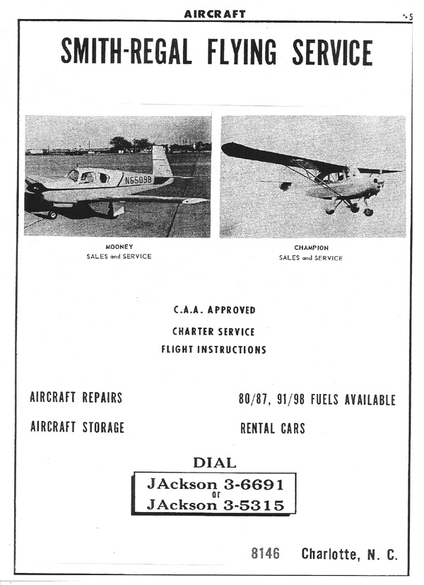 |
|
|
Answer:
The Smith-Regal Flying Service was located at Carpenter’s
Airport on Hwy 160 (Steele Creek Rd) near the intersection
of Westinghouse Blvd. Olin Carpenter was the owner of the
airport. He was a pilot in WWII and upon returning from the
war, built the airport. A business park is there now.
Before the business park was built, part of the runway was
still visible from Westinghouse Blvd. (coming from S. Tryon
St.) on the right just before Steele Creek Rd. If you turned
right on Steele Creek Road, you'd see Carpenter's house and
several other small tenant-like houses about 500 feet on the
right. The runway was behind those houses and ran
from about Westinghouse towards Brown Grier Rd.
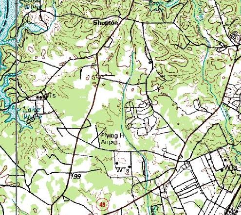
The map below is from a USGS
topological map, apparently from 1984. It shows a "Flying H
Airport" on Westinghouse Boulevard near Steele Creek Road.
This is the location of Carpenter's Airport. The Flying H
Airport was a different airport located near Shopton Road
West. |
|
2. What
was the name of the first manufacturing establishment in Steele
Creek and where was it located and about what year was it built?
What did they make at the mill?
|
Answer: The Rock
Island Woolen Mill was built in about 1848 and many kinds of
wool fabrics were made there. Right before the Civil War
started, they produced the fabric for making Confederate
uniforms. After the war, around 1870, the warehouses for this
company (located in downtown Charlotte) and the mill ceased to
operate. At the time it was operating, it would have been one
of the first mill villages in the Carolinas. The listing for
the sale of the property indicated there were 12 to 15 cottages
located near the mill, plus there was a small Methodist chapel
there which was served occasionally by a traveling minister.
The mill employed approximately 53 people according to the 1850
census records.
By 1852, the
factory produced black and gray cassimeres (sic), some which
were being sold in Wilmington for 87 ½ cents a yard. Tweed,
jeans and kersey were also made, and wool was bought for 25
cents a pound. (From” The History of Mecklenburg County and
the City of Charlotte from 1740 – 1903., Vol. 1. By D. A.
Tompkins, p. 127.)
The mill was
located at the end of Rock Island Road on the Catawba River near
the Beaverdam Creek. Water power was used to operate the mill. |
3. What
was the name of the school in Steele Creek that was built by the
Rosenwald Organization?
|
Answer: McClintock
School on Erwin Road was built by the Rosenwald organization
after the freedom of the slaves in Steele Creek. This black
school is one of only two Rosenwald schools still standing in
Mecklenburg County. McClintock school is now on the Mecklenburg
County Historic Properties list.
For more
information see
McClintock (African-American) School on the Steele
Creek Historical & Genealogical Society web-page. |
4. About
when was Shopton established and what businesses where there and
what could you buy when you went there?
|
Answer: Shopton, which
was shortened over the years from “Shop Town”, began between
1882 and 1890. At that time, Steele Creek Road was called the
“Fort Mill Road” and veered to the east just past the present
store where another road, called the River Road (now Shopton
Road West) veered to the southwest.
Joseph Hayes
built the store that is now called Byrum general Store in about
1883 or 1885. In the area around the store was John
Summerville, the blacksmith, William Thompson, another
blacksmith, John Blanchard, a “boot and shoe maker”, and Rufus
Grier, who operated a saw mill and a cotton gin. The store was
a typical general store where you could buy all of the staples
needed: food, clothes, dishes, farming utensils, and various
other supplies, You could get your horses shoed, have tools made
by the blacksmith, have your cotton ginned, and have lumber
sawed to build your buildings. It was the hub of the
community. |
5. Name
two houses in Steele Creek today that are on the National Historic
Register.
|
Answer: The McDowell
House, located on S. Tryon St. (York Road) where Beam Road
intersects with S. Tryon.
The Neal
House, located near the intersection of Westinghouse Blvd and
Shopton Road West, between Withers Rd. and the Withers Cove
bridge.
Revised answer: The McDowell House
apparently is not on the National Historic Register. Application apparently
was made to place the Neel House on the register, but it is not
clear that this ever occurred. According to the national
Register of Historic Places web site (http://www.nps.gov/nr/),
the Steele Creek Presbyterian Church and Cemetery and the
Hayes-Byrum General Store are on the National Register. |
6. What was the name of this church built in 1883 and where
was it located?
 |
|
|
Answer: Central
Steele Creek Presbyterian Church on S. Tryon St. at
Westinghouse Blvd. This church was built as Central Steele
Creek Associate Reformed Presbyterian in 1883. The “Lower
Steele Creek ARP” (Blackstock, located near Carowinds) and
“Little Steele Creek ARP” located on now Sandy Porter Road
near Olympic High School, merged together to built this
church, which was on property centrally located between the
two churches. Thus, the name of Central Steele Creek. By
1916, many of the members had moved into Charlotte and the
church petitioned the Presbyterian Church to become part of
the Mecklenburg Presbytery. This building was turned into a
Sunday School building when the present sanctuary was built
in 1949. In 1959, this building was torn down and a new
Sunday School building was erected on the site. |
|
7. Why
did so many people leave Steele Creek between 1790 – 1805? Where did they go?
|
Answer: After the end
of the Revolutionary War, the funds of the state were drained
and the state could not pay the militia men for their service.
Property was issued to the state in what is now Tennessee and
the soldiers were paid by receiving land grants in Tennessee.
The size of the grant was based on the rank in service at the
end of the war. These grants started to be issued In 1790 to
1805, and either the soldier himself or his family moved to
Tennessee to take up their grants of land. The many men in
Steele Creek who had fought in the war were getting older and
many of them stayed but their sons moved to obtain more land
than they could have in Steele Creek. In many cases, parents
were left with, in most cases, only their oldest son remaining
to care for them and inherit the land in Steele Creek and the
rest of the sons moved. In a lot of cases, their daughters had
married men who were moving to TN also. So during that
time, the population of Steele Creek was greatly diminished.
There were some generals in the militia that received as much as
12,000 acres in TN. The average for a private was 640 acres.
The other ranks fell in between that in acreage. |
8. What
was the location of one of the biggest festivals held each year in
Steele Creek in the early 1900s where there were games,
picnicking, political speakers, etc.? What type of game was
remembered to be the biggest competition and what was the results of
winning it?
|
Answer: Shopton was
the location of the “festivals”. The annual events had
political rallies with many running for election coming out from
Charlotte to campaign and make political speeches. The rallies
were not just for local candidates but included candidates for
state offices, and people came from all over the area to hear
them. There was no media in that day, other than newspapers
which were expensive, so this was an only opportunity for many
to hear from a candidate.
The highlight
of the day was a tournament that consisted of a horses being
decorated with lowers, and small rings were hung with red cloth
covering them. Men would ride the horses with a type of lance
and try to spear the rings. The winner got to crown the queen
of the tournament. In later years, the horses were replaced by
bicycles. |
9. What is the name of this building? (photo taken between
1917 – 1920).
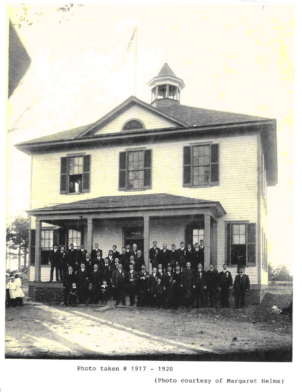 |
|
|
Answer:
This is a picture of the Dixie High School. The school
was located at the intersection of old Steele Creek Road
(later Wallace Neal Road) and the north intersection of
Dixie River Road. (The site of the school has now been
graded away for the new airport runway under construction.)
Dixie school was built in 1896 and was closed in 1926 when
it was consolidated with other schools into Berryhill High
School. |
|
10. Where
was Steele Creek High School located in 1900 – 1923? What happened
to the building?
|
Answer: Steele Creek
High School was located near the intersection of York Rd. (S.
Tryon) and Sandy Porter Road. It was a two story building when
it was built in 1900 and in 1923, it was consolidated with the
newly build Steele Creek School near the intersection of York
Rd. (S. Tryon) and Erwin Road.
After the
Steele Creek High school was closed, the school board deeded the
property back to the community. Because of the condition of the
upper story and roof, it was removed, and a new roof put on the
first floor. It was called Central Community House and many
organizations in the community used it for meetings. In the
early 1990s, the Miller home next door to it and the property
the community house was purchased for commercial use and the
community house was moved to the Steele Creek Athletic
Association ball fields. |
11. What
were the 3 names of the ferry on Yorkville Rd. crossing the Catawba
River into York Co., South Carolina from the 1770s to 1923 when the
Buster Boyd Bridge was built?
|
Answer: In the
Colonial Records of South Carolina is a license issued to the
Bigger family to run a ferry across the Catawba River to the NC
side in 1774. It continued as Bigger’s Ferry until the early
1800s when the Mason family purchased the property on both sides
of the river. It was then called Mason’s Ferry. After the
Mason property on the NC side of the river was purchased by R.
C. Youngblood in 1851, the ferry was then run by a Mr. Wright.
It remained Wright’s Ferry until the new Buster Boyd bridge was
built (Hwy 49-Yorkville – York Rd.) in 1923 at which time Lake
Wylie had been made and the ferry was disassembled and the site
flooded by Lake Wylie. |
12. Who built this home in the 1840s, where is it
located and what famous person is descended from the builder and
owner of this home?
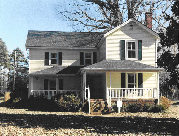 |
|
|
Answer: The home
was built in the 1840s by James Morrow Coffey. He had
several children but one son, Benjamin Morrow Coffey,
continued living in the home for the next generation.
Benjamin married Martha Lucinda Augusta Robinson. One of
their children was Morrow Coffey, who was born in the house.
She married William Franklin Graham, II. To them was born,
William Franklin Graham, the noted “Billy Graham”. The
house is located on Shopton Road. After going past the Fire
and Police Academy, the house is about a mile on past it on
the right side of the Shopton Road. |
|
13. What
High School in Berryhill had a yearbook called “The Pinnacle”?
|
Answer: Dixie High
School |
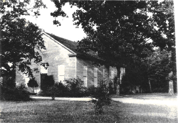
14. What is this building built in 1905 and where was it
located?
 |
|
|
Answer: This is
the 2nd house of worship for Pleasant Hill Presbyterian
Church located on York Road just before the entrance to
McDowell Park on the right. The church was founded in
1836. This church was built in 1905. The 3rd house of
worship was built in 1973, and that Sanctuary is still
standing at the site today. Recently, the new 4th house of
worship was dedicated. The 1905 building remained standing
beside the 3rd building for many years and was finally
removed several years ago to start the new building that is
there today. |
|
15. Where
was Browhill? How did it get its name?
|
Answer: Browhill was
near where Piney Top and Wilmount Roads terminated into Dixie
Road. The old general store was located across the road that
went into the old airport terminal on West Blvd. It was close
to where later the “Ma” Duncan restaurant sat at the corner of
West Blvd and Wilmount Rd. The name was derived from the names
of Brown and Berryhill, two of the families that lived in the
area. Browhill community came into being about the end of World
War I and 20 years later a runway was built for the new air
service coming into Charlotte. Later during World War II, the
air field was expanded to train pilots and that runway began to
replace people who lived in the airport area. After the war
when the airport began to expand, more neighbors were moved from
the area, and of course, today neither Dixie, Browhill, Juneau,
Lodo, or Berryhill school area plus some areas south of the
airport exists. All have been bulldozed away to built two more
runways. |
16. What
is the name of this church and where is it located?
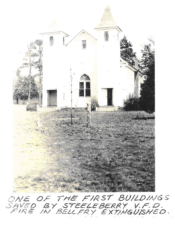
|
|
|
Answer: This is
McClintock Presbyterian Church. It was built probably in the
1870 to 1880 time period. McClintock Presbyterian Church
was the first African-American church in Mecklenburg County.
The slaves were freed after the war and they left the white
churches, Steele Creek Presbyterian and Pleasant Hill
Presbyterian, to form their own church. Prior to their
freedom, they attended the white churches with their masters
where they sat in the balcony but were full members of the
churches. They were baptized in the church and attended
most events there.
|
|
|
After the
Civil War, the minister was removed from the white church
because during the war he thought the slaves should be able
to read and write so they could read the Bible. He took the
list of the African-Americans and helped them form their own
church. The Rev. Samuel C. Alexander was the first minister
of McClintock and after forming it with ex-slaves from the
lower Steele Creek area, he went to the Berryhill area and
formed Mt. Olive Presbyterian Church to serve the ex-slaves
from old Steele Creek Presbyterian Church. He felt the need
for African-American ministers, and he and another minister
from Pennsylvania, where Rev. Alexander was from, started a
school called Biddle Institute in 1786. That school later
became known as Johnson C. Smith University. The first
African-American minister at McClintock was Rev. Ijams.
McClintock’ church and school (built as a Rosenwald school)
on Erwin Road are still standing. The church, after the
fire in the belfry in the 1950s, was changed to its present
day exterior, completely covered with brick, but the inside
of the church is still the same church that was built in
1870 to 1880. As stated in question #3, McClintock school
on the church lot, is on the Mecklenburg Co. Historic
properties list. |
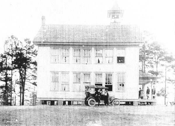
17. What
is the name of this school and what happened to it?
 |
|
|
Answer: The above
school was the Shopton School, first called Shopton Academy,
then Shopton High School. It was closed in 1921. We can’t
find when it was built but have pictures taken of students
there in about 1901. Capt. Robinson, who donated the
property for the school to be built, died in 1900, and it
was thought the school had been there at least 10 years
prior to his death. In 1921, it merged with the Dixie
school in question #9, and the county turned the school over
to the community. It was used for various club meetings and
later burned. It was located about where the I-485 bridge
under Hwy 160 (Steele Creek Rd.) at Shopton is located. |
|
18. What
is the name of this two story school and where was it located?
 |
|
|
Answer: The
Pleasant Hill School, also known as Capps School, was
located at the corner of Youngblood Road and McKee Road near
Lake Wylie. It was built between 1900 and 1905. The first
floor was grades 1 through 6. The second floor was for
grades 7 through 11 (as high as the grades went at that time
in Mecklenburg Co.). The school operated until 1923 when
it was consolidated into the new Steele Creek School built
on York Road at Erwin Road along with Steele Creek High
School (Question 10) and Observer School. Knox school, a one
room school located on Shopton Road West, was also
incorporated with the other two schools to begin at Steele
Creek School.
A house
sits on the location of the Pleasant Hill School today. |
|
|