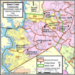
Home Page
Steele Creek News
About The Residents Association
Events
About Steele Creek
Maps of Steele Creek
Local Government
Other Organizations and Sites
Message Board
Contact Us


ELECTION DISTRICTS IN STEELE CREEK

For the 2004 elections, Steele Creek contains six entire voter precincts and parts of two others. Click on the links below to view maps of voter precincts and representative districts in Steele Creek. See a LIST of candidates for 2004 primary and general elections.


Click on map for an enlargement showing voting precincts and polling places in Steele creek.

View a map of 
Congressional District Boundaries
View a map of 
State Senate District Boundaries
View a map of 
State House District Boundaries
View a map of 
County Commissioner and School Board District Boundaries

All portions of Steele Creek within the Charlotte city limits are in City Council District 3.

For more election maps for Mecklenburg County, visit the Mecklenburg County GIS Online web site.

  • To see maps of General Assembly and other districts in the county, select the
    E-Mapper application. Click on "Display Map Viewer," and then "Display a Map District." Then select the district type you would like to see and submit.
  • To find out your election precinct, polling place, and representative districts, select the Voter Information Express application and enter your address.

For other information about elections and voter registration, visit the Mecklenburg County Board of Elections web site.